About
Randy Krum
President of InfoNewt.
Data Visualization and Infographic Design

Infographic Design

Infographics Design | Presentations
Consulting | Data Visualizations

DFW DataViz Meetup

Join the DFW Data Visualization and Infographics Meetup Group if you're in the Dallas/Fort Worth area!

Search the Cool Infographics site

Custom Search

Subscriptions:


Feedburner

The Cool Infographics® Gallery:

How to add the
Cool Infographics button to your:

Cool Infographics iOS icon

- iPhone
- iPad
- iPod Touch


Read on Flipboard for iPad and iPhone

Featured in the Tech & Science category

Flipboard icon

Twitter Feed
From the Bookstore

Caffeine Poster

The Caffeine Poster infographic

Entries in spending (78)

Friday
Jul012011

Client Infographic: Waste in the Texas Energy Market

Waste in the Texas Energy Market from ChooseEnergy.com is a new infographic by InfoNewt and designer Jeremy Yingling.  This one tells the story of how much money is NOT being saved by households that don’t take advantage of lower pricing since Texas has a deregulated electricity market.

As the economy struggles to recover and households continue to cut back on spending, one of the easiest ways to save money might just be in your electric bill. In these tough economic times, consumers realize the importance of watching how every penny is spent. Today we look at the “Waste in the Texas Energy Market” and how pennies can certainly add up quickly to improve consumer finances.

Following the Infographic Release Strategy from InfoNewt, ChooseEnergy also did a great job setting up a dedicated landing page and custom URL for the infographic.  All of their links then drive traffic to this single page.  So the company blog post, Twitter feed and Facebook posts provide additional descriptions and links to this landing page.

While highlighting the fact that the Texas energy market is the 11th largest in the world, the infographic also shows that 48% of the electricity consumed is from residential use.  So what’s the big deal?  On average Texas residents pay about 11.5 cents per kWh for their home electric use when they could be paying 8.5 cents per kWh.   Doesn’t sound like much does it?  Well, those 3 pennies can add up fast and they add up to $3.7 billion for the Texas consumer market.

You can follow ChooseEnergy on Twitter at @texas_electric

Tuesday
Jun142011

Microsoft: The Mobile Commerce Revolution


The Microsoft TAG team has released a new infographic focused on intelligent shoppers.  Mobile Commerce Revolution: Smartphones & Smarter Shoppers looks at the data behind how we use our smartphones to compare prices, look-up coupons, make purchases with our phones and more.

This is a very busy infographic, with some great data hidden inside.  I like the visuals and the isotype style, but there isn’t a cohesive story or clear path for your eye to follow.  The e-commerce sales growth from 2009 to 2015 is a huge data point and should be much more prominent.

Thanks to Nick for sending in the link!

Tuesday
May242011

U.S. Education vs. The World

U.S. Education vs. The World is a very cool infographic from MAT@USC.  You can imagine this data as a boring series of bar charts in an academic report, but the colorful, visual design here is fantastic.  The winding connecting lines can make it a little difficult for the reader to understand the data, but I think it also draws the reader in like a simple puzzle.

We’ve put together this infographic that compares the United States’ education spend and performance versus eleven countries.  The U.S. is the clear leader in total annual spending, but ranks 9th in Science performance and 10th in Math.

Thanks to Sarah for sending in the link!

Monday
May092011

The Obama Energy Agenda: The White House attempts an #Infographic


On Friday, the White House (yes, that White House) released this infographic, The Obama Energy Agenda & Gas Prices.  This is one of the very few “official” infographic designs we’ve seen from the U.S. Government, so I think it deserves a little more critique than normal.  There are some things I like about this one, and some things I don’t.

The Good: 

  • The fact that this was released by the White House, is a really big positive.  I generally praise companies that experiment with infographics to get their messages out, and an official one like this from the government says big things about infographics continuing to grow in relevance in today’s society of information overload.  If you want your information to reach a bunch of people online (especially the younger crowd) then using an infographic is your best bet.
  • Nice layout telling a story.  The best infographics tell a story well, and the progression of topics top-to-bottom tell the story Obama’s team wants to share.  One topic leads into the next.
  • Bold colors.  The dark background stands out nicely in most online news and blog formats, even on the white background color of the White House Blog.  The color gradient matches the new, official White House logo with the blue gradient background you see at the top.  Makes the overall infographic feel very official.
  • Good use of illustrations.  Sometimes, visualizing a point is effectively done with an image or illustration so the reader immediately knows what you’re talking about.  The car with a power cord, the bus, the fuel gauge and the oil wells designed into the separator line near the top.
  • I like the color scheme too.  Some infographics go so crazy with clashing colors it’s hard to read, but the consistent light blue, yellow and white is easy on the eyes.
  • They included a social sharing button at the bottom of the blog posts.  They use a combined social button that expands to show many sharing services.  I generally find that less people actually use combined buttons, but they certainly save screen real estate and there’s a way to share online.  There’s no logo or company name included in this button either, so the White House isn’t endorsing a particular company.
  • I like the line chart.  They removed the y-axis labels and put the data right onto the chart, along with additional comments.  This makes the whole chart easier to understand.


The Bad: 

  • NO DATA SOURCES!  Where did the numbers come from?!?  You want readers to engage and debate your story, not challenge your facts.  Citing all of your data sources keeps the conversation on your story.  This design, without sources, almost invites readers to focus on challenging the facts instead of becoming engaged in the conversation about energy.
  • Way too much text!
  • The infographic above is the blog-size version.  The high-resolution version is tough to find because clicking on the image only takes you to the blog-size image.  Separately, in the text of the White House post, you have to click “Download Full Size” to view the higher-resolution version. (Click the image above to view high-resolution)
  • Text too small.  The font is so small in some places, it’s hard to read, and many people won’t find the text link to the high-resolution version.
  • Not many data visualizations.  Big numbers are not visualizations. and there are only three actual data visualizations (line chart, column chart and color filled factory illustrations).  There are so many more numbers included that should have been visualized to give them context!  
    • How does 35.5 mpg from 2012-2016 compare to the last four years?
    • “Over 2 billion barrels of American crude oil produced in 2010.”  Show the last 20 years to provide context.
    • “…would reduce oil consumption of about 750 million barrels through 2010.”  Is that a lot?  Making the text bold makes it feel important, but it doesn’t give the reader any frame of reference.
  • The stacked column chart could be much better.
    • They could have removed the Y-axis labels and the background lines
    • Legends are evil.  In the 2012 column, they could have identified the color-coding of the different sources of renewable energy instead of putting a separate legend under the chart.  Makes the reader work harder to look back-and-forth at a legend.
    • Why isn’t “Solar” the yellow color instead of “Geothermal”?  Yellow…like the sun.
  • The factory visual at the bottom is tough.  For any shape visualizations, it’s the AREA of the shape that conveys meaning, and I think the designer missed it here.  It looks like the green color height matches the data, but not the area of the factory shape.  Readers understand this intuitively, so to most readers the factory showing 2035 data will just look wrong, even if they don’t know why.
  • No designer credit.  Who designed it?
  • No single landing page.  The infographic is actually included in two different blog posts: The President on Jobs & Gas Prices: Read His Remarks, Download the Graphic on May 6th and Weekly Address: Clean Energy to Out-Innovate the Rest of the World on May 7th.
    • This makes tracking more difficult because they would have to look at links and views for both individual blog posts.
    • The infographic is actually the secondary topic to both blog posts, so it’s never truly highlighted as the focus of the blog post.  It’s just included in blog posts about energy topics.


Don’t get me wrong.  I LOVE that the White House staff is experimenting with infographics, and I hope they do many more in the future.  They just need some more practice. 

What do you think?

Friday
Apr292011

Regular vs. Royal Wedding Costs

Adaptu brings us the Regular vs. Royal: The Cost of Getting Married infographic.

Roses or tulips? Open bar or cash bar? New gown or alter the one you found online? Do you have room to invite former Prime Minister Tony Blair? The only task more stressful than planning a wedding is financing it, and nothing tops a Royal ceremony.

Keeping the cost in perspective, we wanted to compare the average American wedding budget to the Royal wedding between Prince William and Kate Middleton.

Click on the infographic to learn what the typical couple spends on flowers and ponder what botanical masterpiece cost the Royals $800k.

I was inundated with submissions of royal wedding infographics, and sadly only a few of them were good.  I like the fresh design aspect of this one designed by the team at Periscopic.com (I just added them to the Cool Links page).  The increasing size of the trapezoids stacked into a triangle is interesting.  What I can’t tell by observation is if they did the area calculations correctly.

In a visual comparison of shape sizes used to compare numbers in a data visualization, the area of the shapes is what the reader sees as indicative of the value, and in this infographic, but the width and height of each trapezoid is adjusted to maintain the traingle shape and be true to the values represented.

I applaud the effort to try new shapes and experiment with a fresh way to visualize the comparison between values.

Thanks to Dino for sending in the link!

Thursday
Apr142011

Eat, Drink and Be Thrifty: #infographic video

New infographic video from Mint.com,  Eat, Drink and Be Thrify uses their data to visualize the statistics behind monthly spending habits.
So how does your spending on food and dining compare to that of your peers? Using aggregate and anonymized data on Food & Dining spending from Mint.com, we created the video above to highlight some of the most interesting trends we found in Mint’s data, from average transaction at a variety of coffee shops, grocery stores and fast food restaurants, to the time of year when Mint users spend the most — or the least — in those categories.
Thursday
Jun032010

Which Retailers are Closing their Doors?

From Milo.com, Which Retailers are Closing their Doors? is an infographic showing which retail chains in America have closed the most locations.

Although the recession is technically now over, it was not without its victims. And while independent mom-and-pop stores certainly suffered, many chain stores across the country also felt the heat. Few retailers were safe from layoffs and store closings, but the entertainment and apparel industries in particular seem to have bore the brunt of the pain. Below are the retailers that had no choice but to close some, or all, of their doors.

Created by Column Five Media.

For our most recent infographic for Milo, we took a look at which of America’s largest retailers were closing up shop(s). This graphic illustrated the fifty retailers that were closing the most store locations.

Wednesday
Apr282010

Jess Bachman Interview (Death & Taxes 2011 Poster Giveaway!!)  #deathandtaxes

Last week, Jess Bachman (@mibi) from WallStats.com released the new 2011 Death & Taxes poster.  I caught up with Jess (by email) to ask some questions about his huge infographic undertaking.  The high-resolution image of the poster is available now online, and the printed version will start shipping on May 7th.  You can pre-order for $24, and the shipping cost is only $0.75 TODAY (April 28th)

WIN a copy of the poster!  Jess has been kind enough to offer a free poster to a reader of Cool Infographics.  To be eligible, you must tweet (or retweet) a link to this post on Twitter before May 7th, and include the #deathandtaxes hashtag.  I included the hashtag in the post title, so any retweets will be automatically eligible.  NOTE: you must also be following me on Twitter (@rtkrum) so that I can send you a DM if you have won!
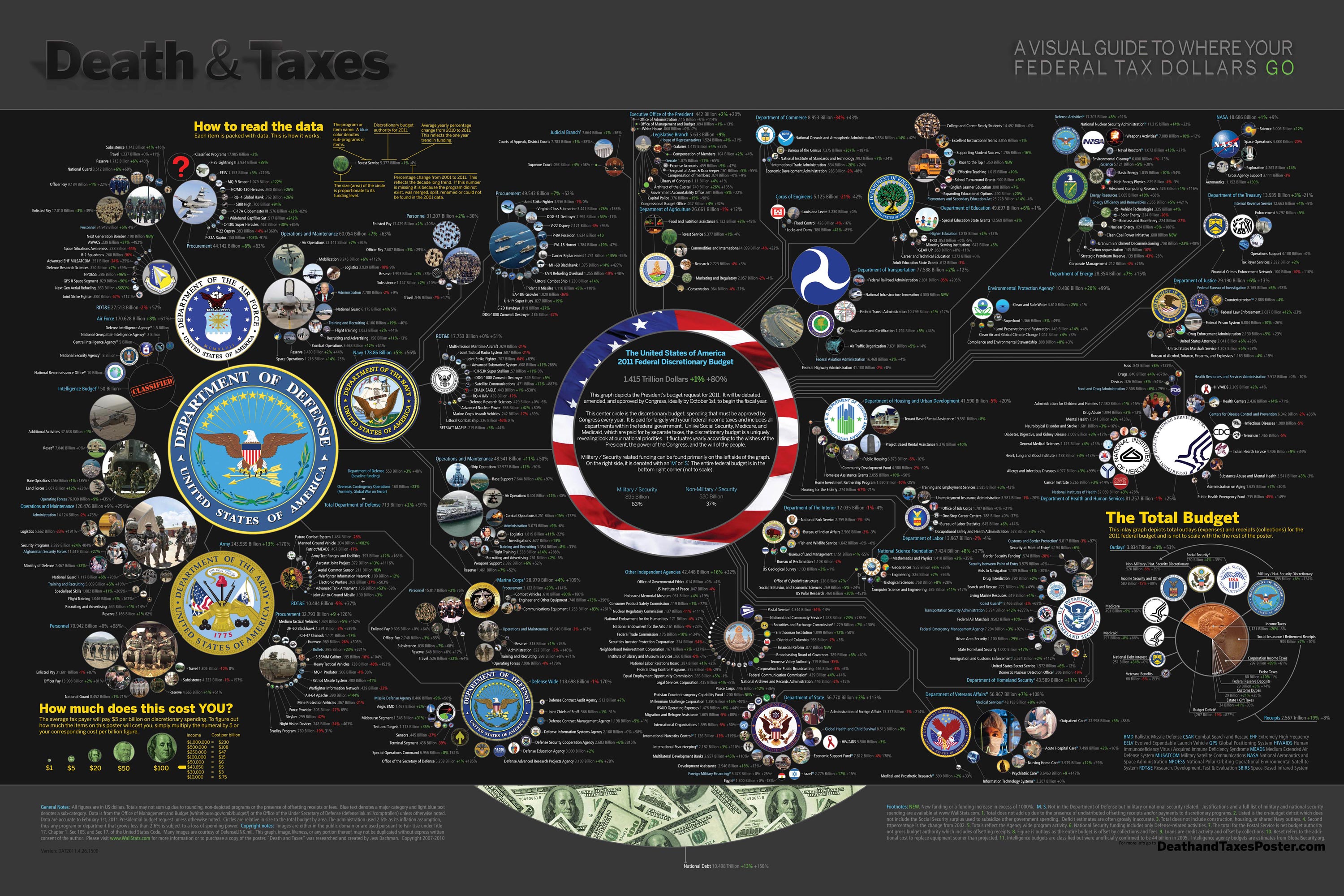
Death and Taxes” is a large representational graph and poster of the federal budget. It contains over 500 programs and departments and almost every program that receives over 200 million dollars annually. The data is straight from the president’s 2011 budget request and will be debated, amended, and approved by Congress to begin the fiscal year. All of the item circles are proportional in size to their funding levels for visual comparison and the percentage change from both 2010 and 2001 is included so you can spot trends.

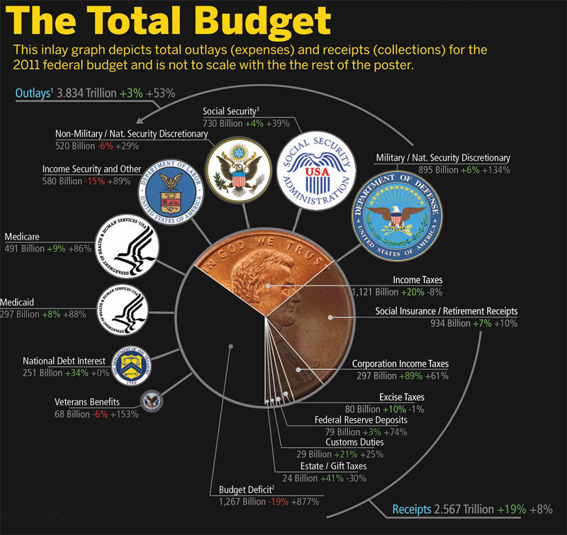
The detail in this poster is stunning, and in this small shot you can see how the total budget request breaks out. Only the “Military/Nat. Security Discretionary” and “Non-Military/Nat. Security Discretionary” portions of the budget request details are displayed in the poster.


Jess was also nice enough to answer a few interview questions I sent him:

Cool Infographics: What software applications do you use for the Death & Taxes posters?

Jess Bachman: The only applications I use are Photoshop and Excel.  Excel is where I in put all the data and it crunches the numbers, adjusts for inflation and calculates diameters.  Photoshop is where I put it all together and the PSD file occasionally exceeds 1 gig so it can be a beast to work with.  Saving takes about 5 minutes.

Cool Infographics: What’s your design process?

Jess Bachman: Normally I start from scratch and layout the images and make them fit; however, this year the budget didn’t change all that much, likely being from the same President, so I was able to keep the 2010 format and change the size of circles.  Of course some things had to be added and removed.  So this year I saved myself about 3 weeks of work just getting right into it, but the design process is grueling.  it’s small tasks, repeated 500 times.

Cool Infographics: What’s the most interesting thing you learned from the data?

Jess Bachman: I can definitely see the differences in Presidents from Bush to Obama.  Lots of reductions on the military side this year and the whole security climate as a whole isn’t as fiscally robust as it was a few years ago.  Much more progressive funding with Obama too.  Every year Bush would cut climate change research, now its back, along with other green tech.  For some reason, public proadcasting gets the hack saw every year no matter who’s in office.

Cool Infographics: Where are some of your favorite places that have the Death & Taxes poster on display?

Jess Bachman: Well it’s always good to see it on display in schools and classrooms.  But I really enjoy hearing from military members who have in their offices or even in station.  I have sent several to Afghanistan.  Critics often say the poster is anti-military, but the military is quite receptive to it, even the former Dept. of Defense Comptroller, Tina Jonas, loved the poster.  Some people from the Dept of Energy’s Oak Ridge Lab displayed the poster on their 30’ Everest computer screen… that was cool too.

Cool Infographics: What’s the hardest part when developing the poster?

Jess Bachman: The hardest part is just getting through all the rote data processing and mindless photoshopping.  The research side is quite fun, and going through the military budgets is a trip with all their classified and hi-tech programs. However, copying and pasting 5,000 times really takes a toll on my creativity and motivation.

Cool Infographics: You said you do a lot of copy & paste work, in what format do you get the data?

Jess Bachman: Some of the government data is in Excel already, but there is no context so I am dubious about working solely with their data sets.  Mostly I pull the numbers from the actual printed budget, which is in PDF form.  So I end up copying and pasting the program name and its funding level for 3 years into Excel, then I copy and paste the program name, funding level, and percentages back into photoshop as a text layer.  Rinse and repeat 500 times.  Many people ask if there was an automated way to create the poster each year and I wish there was, but the confines of the paper make size and fit a manual process.

Cool Infographics: Where do you have them printed, what are the printing specs and why?

Jess Bachman: I get my posters printed from a company called PrintPelican in Florida.  There really are no cheaper prices out there but I opt for a thicker cut of paper than usual.  I get 100# gloss cover which is a few shades from a business card in thickness.  To be honest, they have screwed up my order a few times over the years but we have always managed to work it out.  I usually print runs of 1000-2500 and always 24” x 36”.

Cool Infographics: How do you handle all of the printing and shipping of the posters?  Do you tube them yourself?

Jess Bachman: I used to do it all myself.  I had a 400lb brick of posters next to my bed, and 12 giant boxes of tubes all over the house, and I would roll pack and ship them all.  Now I use two shippers who do fulfillment of the orders for me.  For a while I would send them the orders and addresses weekly but I have offloaded that duty as well.  I think the self shipping method is a good lesson in customer service and its good to know your product inside and out, but after while my time became more valuable than stuffing tubes could afford.

Cool Infographics: You’ve used a few different online zoomable image services in the last few years, what have you learned?

Jess Bachman: There are lots of zooming options out there and new ones seem to pop up all the time.   I used Zoomify until it felt too clunky and slow, then Zoomorama which I really loved for its performance and options.  This year I experimented with an self hosted open source app called Open Zoom and it certainly was a slick and great user experience, unfortunately the demands it placed on my server from huge inflows of traffic proved too much, taking down the whole site.  So I had to switch to my backup, which was Closr.it, and let them deal with server demands.  Closr.it has been very attentive to my needs and I have found that most developers will work with me to tailor a custom solution if I ask.  The zooming apps keep getting better so I expect to keep changing apps as long as the space keeps innovating.

Cool Infographics: You mentioned the 30’ display, have you printed it out in larger sizes?

Jess Bachman: No, I have not printed it out any larger.  The file being Photoshop, and the images being mostly rastered do not allow quality printing beyond the poster size.  The file is 300 dpi so I could get away with a slightly larger size, but oversize printing is expensive and who wants a poster that big anyways. 

Cool Infographics: Where do the images come from?

Jess Bachman: Most of the military images come from defenseLINK, which is a great repository for hi-res military photos.  Other images come from stock photography sites for the most part.  It does help that most government logos are round.  I suppose it’s just an old school way of doing things, government seals and all.  The design aesthetic amongst government logos is really all over the map though, and its quite interesting.  Some look like that are from the 1700’s, and some from the 2700’s.

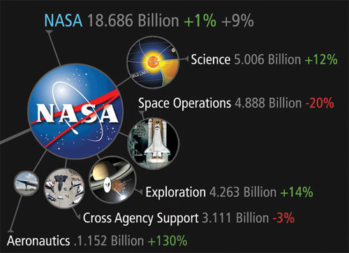
 There was one correction to the online version that Jess has posted:

So I totally had the wrong data for NASA on the visual. Here is the corrected image, which reflects what you have been reading in the news. Science up, space down. I fixed it before it was printed, don’t worry.

You can view the image, buy the poster and more at the new site DeathandTaxesPoster.com.

SPECIAL: If you pre-order the poster TODAY (April 28th) shipping is only $0.75!

Thursday
Apr222010

China's Global Investments - interactive map


Jon Bruner from Forbes.com has designed and posted an interactive timeline/map of the major investments China has made all over the world in the last five years.

When you first see the map, it’s an animated timeline that highlights which countries China invested in each month since March 2005.  The animation completes when it reaches December 2009, and then you can select a particular year by clicking on the total investment bars across the bottom or see the details behind any particular investment by mousing over one of the bubbles.  The bubble sizes represent the size of the investments.

Since 2005 Chinese firms and arms of the Chinese government have invested hundreds of billions of dollars in foreign companies and raw materials. Each dot on this map tracks one of those investments, with larger dots representing larger investments. Explore the map by rolling over and clicking on the dots and timeline.

Thanks Jon for the link!

Thursday
Apr222010

Follow the Money - infographic video

Follow the Money” is a video summarizing the results from the project by Northwestern University grad students Daniel Grady and Christian Thiemann.  Using data from the website Where’s George?, they have been able to track the movement of U.S. paper currency.  What can you learn from this?  That there are natural borders within the U.S. that don’t necessarily follow state borders, and it can also be used to predict the spread of disease because it maps movement of people within the U.S.

From Maria Popova on BrainPickings.org: This may sound like dry statistical uninterestingness, but the video visualization of the results is rather eye-opening, revealing how money — not state borders, not political maps, not ethnic clusters — is the real cartographer drawing our cultural geography.  The project was a winner at the 2009 Visualization Challenge sponsored by the National Science Foundation and AAA.


From Manuel Lima on VisualComplexity.com: Some places, such as Los Angeles, California, have many bills passing through it from across the nation, while others, such as Anderson County in Tennessee - Grady’s home - have bills circulating mainly within a more local neighborhood. Shown here are images from the video.  The data from the Where’s George? project is in fact so pertinent that is also being used by researchers to predict the spread of flu across the United States.

You can see the Northwest project site, which has a much more adademic title “Community Structure in Multi-Scale Transportation Networks”.

Rendered using Processing 1.0.6.  Found on VisualizingEconomics.com, VisualComplexity.com and Maria Popova has a good article on BrainPickings.org.