The United States of Craigslist
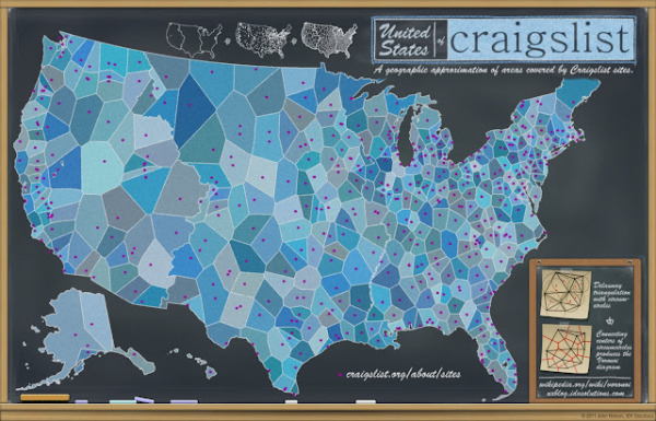
Welcome to The United States of Craiglist! This infographic map, found on the IDV User Experience blog, shows approximately how craigslist divides its geographic zones across the U.S.! Very important for a website who bases its usefulness on location!
WHY? Locality is inherent to the value of craigslist; I go to craigslist.org but I get kicked over to the local instance of craigslist (my IP address sources me to somewhere in the illustrious Lansing, MI). But how does craigslist know where to send me? Some mysterious system of assigning a geocoded IP address to just the right site must be in place…I wonder what that map looks like.
When Ian Clemens proposed the idea, I looked around to find an existing map of craigslist sites-to-areas -maybe even find the lookup that they themselves use. I couldn’t find anything like it.
Whether it matches their system well or not, here is a map that approximates geographic coverage to individual sites using a Voronoi process as a base (more info on process below). It is at least a start at visualizing the geographic coverage and distribution of the community-driven instances of craigslist. Shapes like this might provide some useful context for other data, demographic or market information, for instance. Also, when pulled into VFX, it can serve as an input to some spatial querying on those other metrics.
It’s worth noting that this is not from Craigslist at all, but an outside analysis of the cities from the craigslist site and approximates the geographic areas covered by each. A complete post about how this map was generated is available here, and they have even made all of the data files available in a number of different formats. Bonus!
Craigslist doesn’t care about state lines, counties, time zones or voting districts. They care about defining an area that covers certain population levels that effectively use their service.
Thanks to Jim for sending in the link!
 Location,
  internet,
  map,
map,  social media,
  web
web 


Reader Comments (3)